
12 Apr. The Israelites journey north to Moab
“The Israelites went and camped at Oboth. They went from Oboth to Iye Abarim, in the desert of Moab. From there they went and camped in the Zered Valley. From there they went and camped across the Arnon, in the desert just inside the Amorite country.”
“The Arnon is the border between the Moabites and the Amorites. That is why the Book of the Wars of the LORD says, ‘… and Waheb in Suphah, and the ravines, the Arnon, and the slopes of the ravines that lead to the settlement of Ar. These places are at the border of Moab.’”
“The Israelites went from there to Beer; a well is there where the LORD said to Moses, ‘Gather the people and I will give them water.’ Then the Israelites sang this song:
‘Pour out water, well!
Sing about it.
Princes dug this well.
Important men made it.
With their sceptres and poles, they dug it.’”
“The people went from the desert to Mattanah. From Mattanah they went to Nahaliel and on to Bamoth. From Bamoth they went to the valley of Moab where the top of Mount Pisgah looks over the desert.”
(Numbers 21:10-20)
In c.1407BC, thirty-eight years after the spies had been sent out from Kadesh to survey the 'promised land' (see Deuteronomy 2:14), the Israelites moved north again towards Canaan (see 8 on the map on 2 April).
They avoided Edom by travelling through the mountainous region to the east of the River Jordan past Zalmonah and Punon (meaning ‘precious stone’). They camped at Oboth and Iye Abarim (meaning ‘ruins of Abarim’) and crossed the deep valley of the River Zered (the Wadi Hasa, which flows into the south east corner of the Dead Sea) to enter Moab.
The Mountains of Moab (reaching about 3000 feet / 900 m above sea level) form a high plateau running along the eastern side of the Dead Sea to the north of the kingdom of Edom, in modern-day Jordan. The people of Israel travelled north along this high plateau.
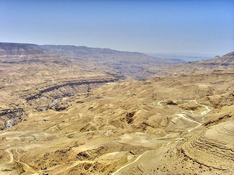
The Israelites avoided any confrontation with their distant relatives, the Moabites, as they travelled north through the Mountains of Moab to the steep-sided gorge of the River Arnon (the Wadi Mujib, which enters the Dead Sea opposite En Gedi) (see 9 on the map). This gorge marked the border of the territory of the Amorites, who occupied the northern part of Moab.
The Israelites then continued across the dry limestone plateau to Beer (meaning ‘a well’) and travelled via Mattanah, Nahaliel and Bamoth to “the valley of Moab where the top of Mount Pisgah looks over the desert” (Numbers 21:20). A ‘pisgah’ is a ridge or viewpoint crowning a hill – Mt Nebo, for instance, has a pisgah overlooking the Plains of Moab - so a more accurate translation would say, 'to the valley of Moab where the top of the mountain ridge overlooks the desert.'
The King’s Highway – the main north-south trading route along which the Israelites travelled – kept to the high limestone plateau some 4300 feet / 1300 m above the Jordan Valley which lay to the west. To the east, the plateau was separated from the Arabian Desert by low, rolling hills. The lower land, bordering the River Jordan to the west of the Mountains of Moab, was called the Plains of Moab.
The high plateau of Moab is now largely a dry and desolate place, with many isolated remains of deserted villages dating from Roman and Byzantine times. Today, only a few nomadic Bedouin Arabs live in the area.
The photo (by Effi Schweizer) shows the Wadi Mujib (the River Arnon) as it cuts through the Mountains of Moab.
You can read more about the Moabites @ https://www.thebiblejourney.org/biblejourney2/26-the-journey-continues-from-sinai-to-moab/the-israelites-journey-north-to-moab/